The Cavalry Battles In Loudoun County

By Heidi Baumstark
It’s called horse country for a reason. Why at one time, horses outnumbered people in Loudoun County, known as the horse and hunt capital of Virginia. From the nation’s oldest horse show (Upperville Colt & Horse Show, 1853), to alluring fox hunts, and famous Washingtonians like the Kennedys, Loudoun continues to entice visitors to its continuous circle of history and horses.
But during the Civil War, horses played a much different, harder role. Instead of horses for pleasure, Loudouners witnessed pounding hoofs and whinnying cavalry in three battles in the summer of 1863 up and down a ten-mile stretch of U.S. Route 50 between Aldie and Upperville. At that time, the road was called Ashby’s Gap Turnpike; today, it’s John Mosby Highway. It became the site of three cavalry battles known as the prelude to the Battle of Gettysburg, which was the turning point of the Civil War favoring the Union.
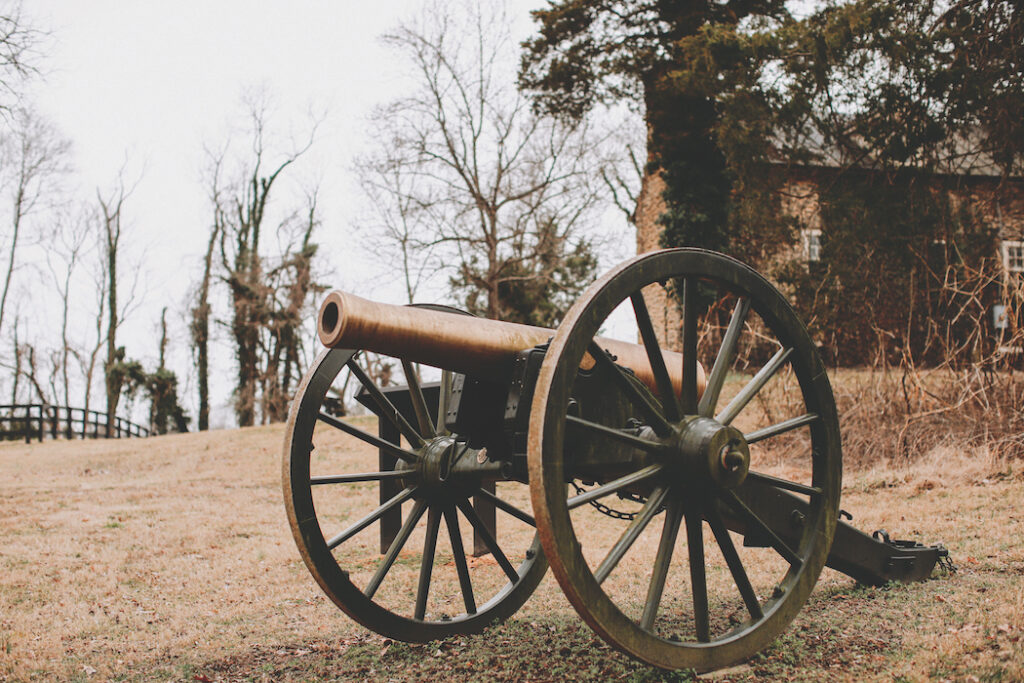
(Above: Cannon at Mt. Defiance Historic Park. Photo by Jennifer Gray.)
In a three-part lecture series titled “Prelude to Gettysburg: Cavalry Battles in Loudoun County,” local historian Richard T. Gillespie, Historian Emeritus for the Mosby Heritage Area Association (MHAA) and Volunteer Guide at NOVA Parks, offered an in-depth account of these three battles that erupted in Loudoun from June 17-21, 1863. These battles are often overlooked but proved the worth and fighting power of both northern and southern cavalrymen and their four-legged mounts.
Gillespie’s first lecture was on Jan. 9 at Cana Vineyards and Winery featuring the Battle of Aldie (June 17, 1863); the second was on Jan. 30 at Mt. Defiance Cider Barn about the Battle of Middleburg (June 19, 1863); and the third was on Feb. 20 at Slater Run Vineyards, which detailed the Battle of Upperville (June 21, 1863) at Goose Creek Bridge. Each program was in the vicinity of all three battles, which were sandwiched between the famous battles of Brandy Station (June 9, 1863) and Gettysburg (July 1-3, 1863). On Jan. 30 at Mt. Defiance Cider Barn in Middleburg, Lorraine Moffa, programming coordinator for Loudoun County Public Library, welcomed the packed house of history buffs, adding, “We’re honored to partner with NOVA Parks to provide these programs,” and thanked Mt. Defiance for hosting the event.
Tracy Gillespie (Richard’s wife) is the Historic Site Manager of all of the NOVA Parks properties related to these battles: Aldie Mill (Battle of Aldie), Mt. Defiance Historic Park (Battle of Middleburg), and Goose Creek Bridge (Battle of Upperville), and said, “We’re fortunate that NOVA Parks has the land of these three battles that happened in June 1863.”
Richard Gillespie opened his lecture on the Battle of Middleburg at Mt. Defiance Cider Barn remarking how the combination of history and alcohol make for an interesting pair. He pointed out that this portion of Route 50 “is where we saw some of the heaviest cavalry fighting.” This section of Route 50 after Gilbert’s Corner is called John Mosby Highway for a reason: named after the ever-evasive “Grey Ghost” who paraded along this route during the Civil War causing havoc for the Union and heroic exploits for the Confederates. It’s the location of the second largest cavalry battle in the western hemisphere.
About one mile west of Middleburg is Mt. Defiance Historic Park, a five-acre portion of core battlefield where the Battle of Middleburg was fought on June 19, 1863, which was the mid-point of the 1861-1865 Civil War. Just ten days prior was the Battle of Brandy Station in Culpeper, known as the largest single cavalry engagement on American soil, and was a major surprise that the Union cavalry was becoming strong and couldn’t be underestimated.
In June 1863, Confederate Maj. Gen. J.E.B. Stuart was in Loudoun trying to collect intelligence. He was in the little mill village of Aldie where fighting occurred on June 17, 1863. UVA-trained John S. Mosby knew what his boss, Stuart, needed to know and gathered intelligence at the Beveridge House (today’s Red Fox Inn in Middleburg). Now the Confederates had gained significant intel from the Union, and Mosby took this information back to Stuart. Gillespie added, “And all the maidens came out to see Stuart in the town of Middleburg. They came to get a glimpse of his red hair and bright blue eyes—and to touch his horse’s tail.”
On June 18, troops regrouped on both sides. Stuart’s men buy time and slowed things down. They didn’t want to fight directly in town; so, he abandoned Middleburg and severe fighting broke out near The Plains Road, the location of today’s National Sporting Library and Museum. Confederates moved about one mile west to a property called Mt. Defiance, which includes a cluster of 19th century stone buildings: a tavern, blacksmith shop, and blacksmith cottage, which are all part of Mt. Defiance Historic Park. During the war, the Barton family owned the tavern but were visiting relatives in Baltimore at the time of the battle.
Stuart’s troops fell into place and John Irvin Gregg’s Union brigade was ordered to head west toward Mt. Defiance. The area around the blacksmith shop—at the intersection of the old Zulla roadbed and Route 50—was where the Battle of Middleburg was fought. The conflict intensified by noon on that sweltering June 19, 1863. The Union’s 1st Maine Cavalry were fighting dismounted from their horses, and the outnumbered Confederates were almost overrun by the 1st Maine. There was hand-to-hand fighting, sabers swinging, and pistols and shot guns firing near the blacksmith shop.
Today, a 12-pound Napoleon howitzer cannon stands in the 19th century old Zulla roadbed that the Confederates used as a defensive position. Stacked stone walls bordering Mt. Defiance were strategic to provide excellent cover for Confederate soldiers who were dismounted and in the woods; those stone walls still stand today. Gillespie said, “Both Union and Confederate soldiers were hiding behind stone walls that were left and right along the turnpike. They’re popping up from behind the walls and fighting each other.”
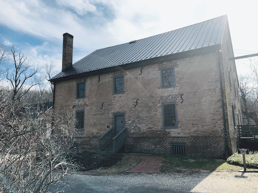
(Above: Aldie Mill on Route 50 in Aldie, near where the Battle of Aldie was fought on June 17, 1863. Photo by Heidi Baumstark.)
One of those fighters at Mt. Defiance was Heros von Borcke, a Prussian cavalry officer in the Confederate army. “He fell in love with Stuart’s ways. He loved the plume in his hat, so he had to have one, too,” Gillespie added. Though von Borcke was wounded at the Battle of Middleburg by a bullet in his neck while mounted on his horse, he survived, and returned to his native Prussia. The bullet was never removed, and he later died in 1895 as a result of his wound.
Around 6 p.m. on June 19, 1863 a nasty storm rolled in, ending the Battle of Middleburg and resulting in about 400 casualties. Churches became hospitals, including Aldie’s Mt. Zion Church where graffiti by soldiers can be seen on the walls.
The outcome? Gillespie said, “Union cavalry essentially won each of these three battles and showed what we could expect looking ahead. But Stuart succeeded in the campaign because Federal cavalry never accomplished their mission of getting through the [mountain] gaps to discover Lee’s location; so, Lee’s corps passed north unhindered.” Stuart basically screened Lee’s invasion route to the north, sparring with Maj. Gen. Alfred Pleasonton’s Union cavalry. (Stuart and Pleasonton each commanded the cavalry corps of their respective armies.)
Against popular opinion, the naming of Mt. Defiance has nothing to do with the Civil War. Instead, the name comes from an earlier battle between two prominent families: the Chinns and the Powells who were feuding in the early 1800s over dividing lines on their land. After court proceedings settling the issue in 1814, the Chinns named their parcel Mt. Recovery to honor the reacquisition of their land; and Burr Powell (son of Middleburg founder, Leven Powell) built on the portion of his tract a house called Mt. Defiance—that decades later—would become the site of the Battle of Middleburg.
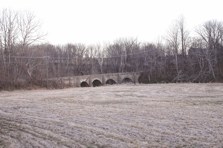
(Above: Goose Creek Bridge in Upperville is the location of where the Battle of Upperville was fought on June 21, 1863. Photo by Jennifer Gray.)
The town was named Middleburg since it was the midway point on this major trade turnpike (Route 50)—a toll road—that connected the seaport of Alexandria to the Shenandoah Valley city of Winchester. But originally, Middleburg was known as Chinn’s Crossing, a tiny hamlet in what was still the colony of Virginia with four buildings centered around Chinn’s Ordinary, a tavern built by Joseph Chinn out of local fieldstone. It became a popular stopping point for traveling colonists, and around 1748, was visited by young surveyor, George Washington. A placard on the stone building states the inn was established circa 1728 and is thought to be one of the oldest continuously operated inns in Virginia and the U.S. In 1812 this stone tavern was called Beveridge House, now, the iconic Red Fox Inn. It was here where Stuart met with Mosby and his rangers in June 1863 discussing their war strategy upstairs in a room that today is called the Jeb Stuart Room, while wounded soldiers were cared for in the tavern below after the battles up and down Ashby’s Gap Turnpike.
Caroline Mastin, tasting room manager at Middleburg’s Greenhill Winery & Vineyards, attended the lecture at Mt. Defiance Cider Barn. She grew up in Fredericksburg and loves history. Both of her grandfathers were history professors. She said, “I actually grew up playing on Civil War cannons, and the church I grew up in was a Civil War hospital.” Her husband, Christian Reese, also attended the lecture, and together, they often attend similar programs. Mastin said, “At Greenhill, we’d love to host programs like these; we have so much history on our property; we have Little River running right through our property and it would be a perfect place for these types of events.”
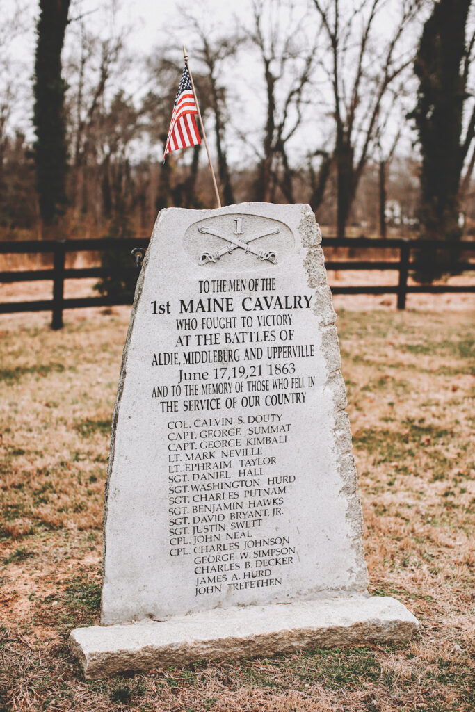
(Above: Memorial at Mt. Defiance Historic Park. Photo by Jennifer Gray.)
Mark Schroeter of Middleburg works at Leesburg’s Oatlands Historic House and Gardens, which is listed on the National Register of Historic Places, built circa 1804. According to the 1860 census, Mrs. Elizabeth O. Carter of Oatlands holds the record for the largest slaveholder in Loudoun County with 128 slaves. Schroeter said, “I didn’t know about the Battle of Middleburg, and I know lots of local history since I work at Oatlands.”
Gillespie ended, “On one of Loudoun’s most travelled roads and one of its most scenic—through the efforts of NOVA Parks, American Battlefield Trust, Mosby Heritage Area Association, and others—we’ve preserved the place where the second largest cavalry battles of the western hemisphere were fought [on Route 50]. These were events that changed the way we do war, events that were the making of the U.S. cavalry that would be critical in winning the Civil War for the federal government. And yet most [people] have no idea that these things exist and can be easily visited. That’s the reason NOVA Parks collaborated with Loudoun County Public Libraries to see this series come to fruition.” Thanks to dedicated preservation efforts, we can walk the fields and drive the roads where cavalrymen—and their trusted horses—made history. ML
Mt. Defiance Historic Park, located at 35945 John Mosby Highway in Middleburg, is open daily during daylight hours. Visit NOVA Parks or call 703-327-9777 for more information. Mt. Defiance Cider Barn is located at 495 E. Washington Street, Middleburg.
This article first appeared in the March 2020 issue of Middleburg Life.